

Research areas
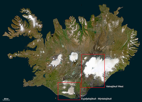
The two research areas shown on a RapidEye satellite imagery mosaic (imagery © BlackBridge AG)
Eyjafjallajökull - Mýrdalsjökull
- The 580 km² large Mýrdalsjökull with the subglacial central volcano Katla is located few kilometers east of Eyjafjalljökull. Both volcanoes are connected by the mountain saddle Fimmvörðuhals.
- About 15 ice cauldrons appear on the Mýrdalsjökull ice cap and show the high geothermal activity of Katla.
- The last destructive glacial outburst flood occured in July 2011. A 128 m long bridge over the main road along the South coast was destroyed and disrupted the traffic for a whole week.
- With 20 eruptions during the past 1100 years, Katla is one of the most active volcanoes in Iceland. According to the eruption cycle, another subglacial eruption is expected.
- Shortly after the past eruptions at Eyjafjallajökull in 920, 1612 and 1821-23, an eruption of Katla volcano happened. A connection between the two volcanic systems is suspected.
Vatnajökull West
- The 8080 km² large Vatnajökull plateau glacier coveres several central volcanoes (e.g. Grimsvötn, Bárðarbunga) and fissures (e.g. Gjálp), most of them located in the western part.
- The Grimsvötn volcanic system is recently very active. Four eruptions have taken place in the past 15 years. The latest eruption happened in May 2011. The produced ash cloud reached up to a height of 19 km and caused the cancellation of about 900 flights in Northern Europe.
- An eruption at Gjálp in 1996 caused a tremendous meltwater torrent. A discharge of up to 45.000 m³/s was measured. The caused damage to infrastructure is estimated to 10 million Euros.
- Regularly outburst floods occur at Skaftá river south west of Vatnajökull. The most recent one happened on 20 January 2014. During this event our early detection system using TerraSAR-X satellite data proved to be successful (see RESULTS).
- On 31 August 2014 a fissure eruption started at Holuhraun, north of Vatnajökull, and lasted for six months. Along with this event high seismic activity and ice subsidence occured at Bárðarbunga (see NATURAL HAZARDS).