

Remote Sensing and GIS data
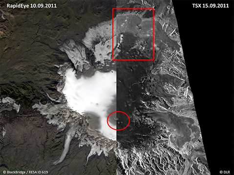
Comparison of an optical RapidEye with a radar TerraSAR-X (TSX) satellite image of Mýrdalsjökull glacier. Marked in red is the area of the 2013 fieldwork at Sléttjökull outlet glacier in the north as well as the two ice cauldrons, which occured during the glacial outburst flood on 9th July 2011.
Remote Sensing data
- TerraSAR-X Stripmap time series since 2010 (spatial resolution 1.25 m, repeat pass cycle 11 days, up to 2 images per day possible)
- TerraSAR-X Staring Spotlight images since August 2013 (spatial resolution up to 20 cm)
- RapidEye optical images since 2011 (spatial resolution 5 m, about 500 nearly cloud-free image tiles)
- TanDEM-X digital elevation models since September 2011 (resolution ~6m)
- LiDAR elevation data from summer 2010, 2011 and 2012 (vertical accuracy 50 cm)
- HRSC data from August 2006 (spatial resolution 20 cm)
- UltaCam data from August 2010, August/Sep. 2014 and September 2015 (spatial resolution up to 11 cm)
Advantages of near real-time monitoring with TerraSAR-X radar satellite data:
- cost-efficient
- weather independent
- unaffected by the volcanic hazard
GIS data
- Meteorological data (for interpretation of the radar imagery)
- Seismicity
- Chemical and physical data of the glacial rivers (e.g. fluorine, conductivity)
- Glacier mass balance
- Glacier flow behaviour